A Closer Look At The Pits Of Pluto

On July 14 the telescopic camera on NASA’s New Horizons spacecraft took the highest resolution images ever obtained of the intricate pattern of “pits” across a section of Pluto’s prominent heart-shaped region, informally named Tombaugh Regio. Mission scientists believe these mysterious indentations may form through a combination of ice fracturing and evaporation. The scarcity of overlying impact craters in this area also leads scientists to conclude that these pits – typically hundreds of yards across and tens of yards deep – formed relatively recently. Their alignment provides clues about the ice flow and the exchange of nitrogen and other volatile materials between the surface and the atmosphere. The image is part of a sequence taken by New Horizons’ Long Range Reconnaissance Imager (LORRI) as the spacecraft passed within 9,550 miles (15,400 kilometers) of Pluto’s surface, just 13 minutes before the time of closest approach. The small box on the global view shows the section of the region imaged in the southeast corner of the giant ice sheet informally named Sputnik Planum. The magnified view is 50-by-50 miles (80-by-80 kilometers) across. The large ring-like structure near the bottom right of the magnified view -- and the smaller one near the bottom left -- may be remnant craters. The upper-left quadrant of the image shows the border between the relatively smooth Sputnik Planum ice sheet and the pitted area, with a series of hills forming slightly inside this unusual “shoreline.” Credits: NASA/JHUAPL/SWRI
On July 14 the telescopic camera on NASA’s New Horizons spacecraft took the highest resolution images ever obtained of the intricate pattern of “pits” across a section of Pluto’s prominent heart-shaped region, informally named Tombaugh Regio. The image is part of a sequence taken by New Horizons’ Long Range Reconnaissance Imager (LORRI) as the spacecraft passed within 9,550 miles (15,400 kilometers) of Pluto’s surface, just 13 minutes before the time of closest approach. Credits: NASA/JHUAPL/SWRI

Last Weeks Close-up In Color

This enhanced color mosaic combines some of the sharpest views of Pluto that NASA’s New Horizons spacecraft obtained during its July 14 flyby. The pictures are part of a sequence taken near New Horizons’ closest approach to Pluto, with resolutions of about 250-280 feet (77-85 meters) per pixel – revealing features smaller than half a city block on Pluto’s surface. Lower resolution color data (at about 2,066 feet, or 630 meters, per pixel) were added to create this new image. The images form a strip 50 miles (80 kilometers) wide, trending (top to bottom) from the edge of “badlands” northwest of the informally named Sputnik Planum, across the al-Idrisi mountains, onto the shoreline of Pluto’s “heart” feature, and just into its icy plains. They combine pictures from the telescopic Long Range Reconnaissance Imager (LORRI) taken approximately 15 minutes before New Horizons’ closest approach to Pluto, with – from a range of only 10,000 miles (17,000 kilometers) – with color data (in near-infrared, red and blue) gathered by the Ralph/Multispectral Visible Imaging Camera (MVIC) 25 minutes before the LORRI pictures. The wide variety of cratered, mountainous and glacial terrains seen here gives scientists and the public alike a breathtaking, super-high-resolution color window into Pluto’s geology.Credits: NASA/JHUAPL/SWRI

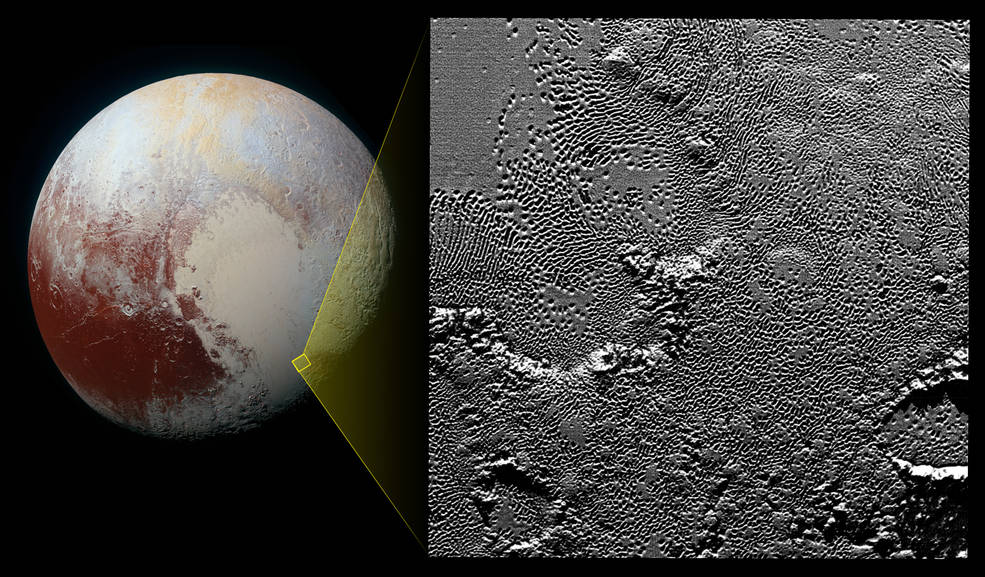
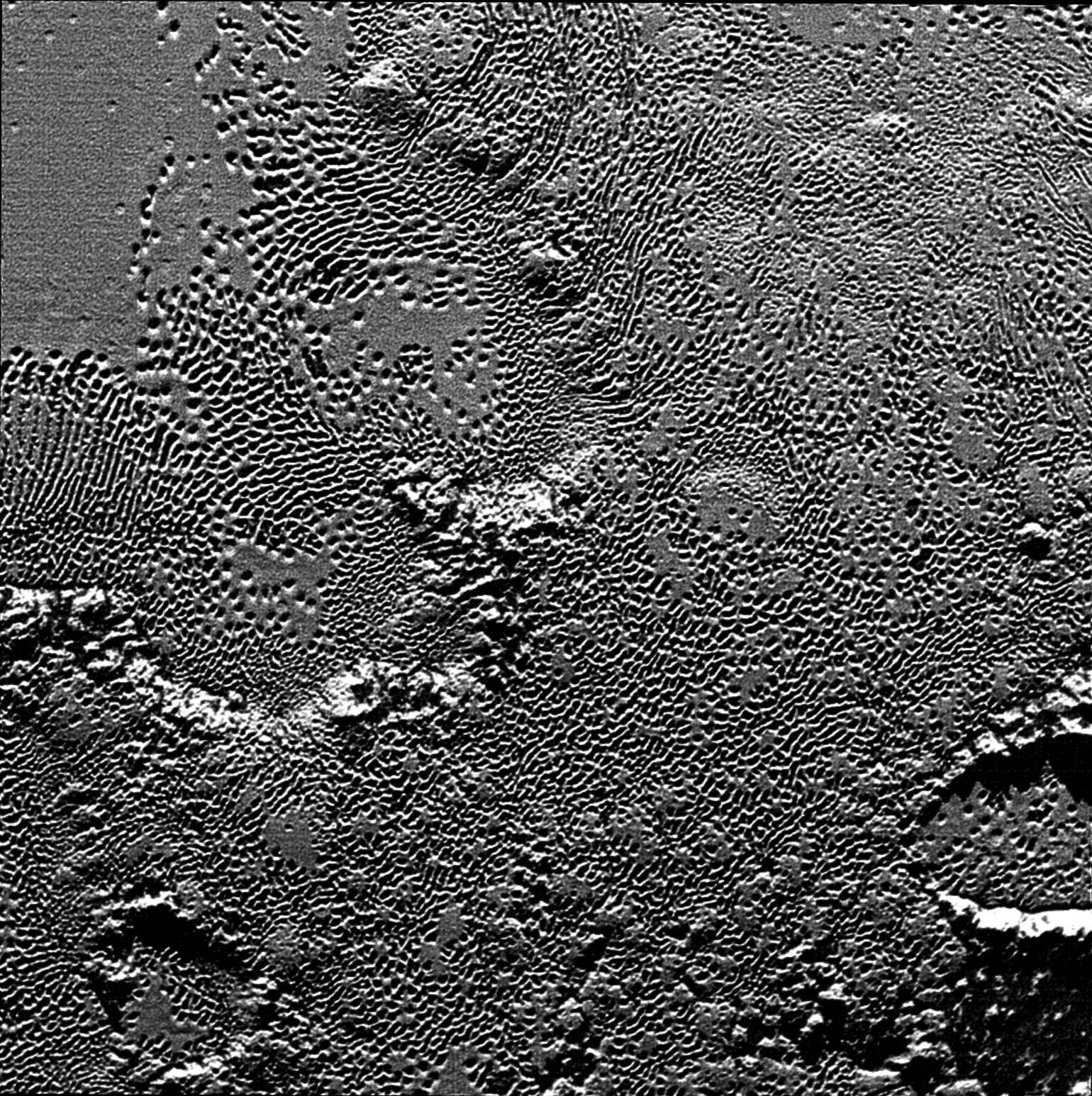
New Visualization of the Space Environment at Pluto

Though the vacuum of space is about a thousand times emptier than a laboratory vacuum, it’s still not completely empty. The sun releases a constant stream of particles called the solar wind—as well as occasional denser clouds of particles known as coronal mass ejections, or CMEs—both containing embedded magnetic fields. The density, speed, and temperature of these particles, as well as the direction and strength of the embedded magnetic fields, make up the space environment. To map the space environment at Pluto, scientists combined the predictions of several models—and looked at events that had long since passed Earth. "We set the simulation to start in January of 2015, because the particles passing Pluto in July 2015 took some six months to make the journey from the sun," said Dusan Odstrcil, a space weather scientist at Goddard who created the Enlil model. The Enlil model, named for the Sumerian god of the wind, is one of the primary models used to simulate the space environment near Earth and is the basis for the New Horizons simulation. The new, combined model tracks CMEs longer than ever before. Because particles must travel for many months before reaching Pluto, the CMEs eventually spread out and merge with other CMEs and the solar wind to form larger clouds of particles and magnetic field. These combined clouds stretch out as they travel away from the sun, forming thin ring shapes by the time they reach Pluto—quite different from the typical balloon shape of CMEs seen here at Earth. Credits: NASA/JHUAPL/SWRI

To access the full features of Pluto Safari please download the FREE app for iOS from the Apple App Store or Pluto Safari: New Horizons for Android from Google Play.

Alternatively, if you have SkySafari or Pluto Safari installed you could download the simulation settings file here.