New Horizons Returns The Sharpest Views Of Pluto

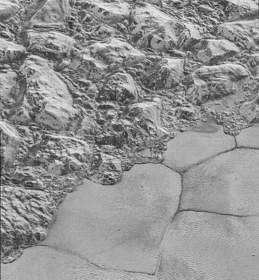
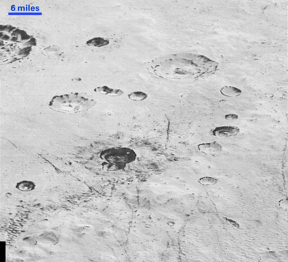
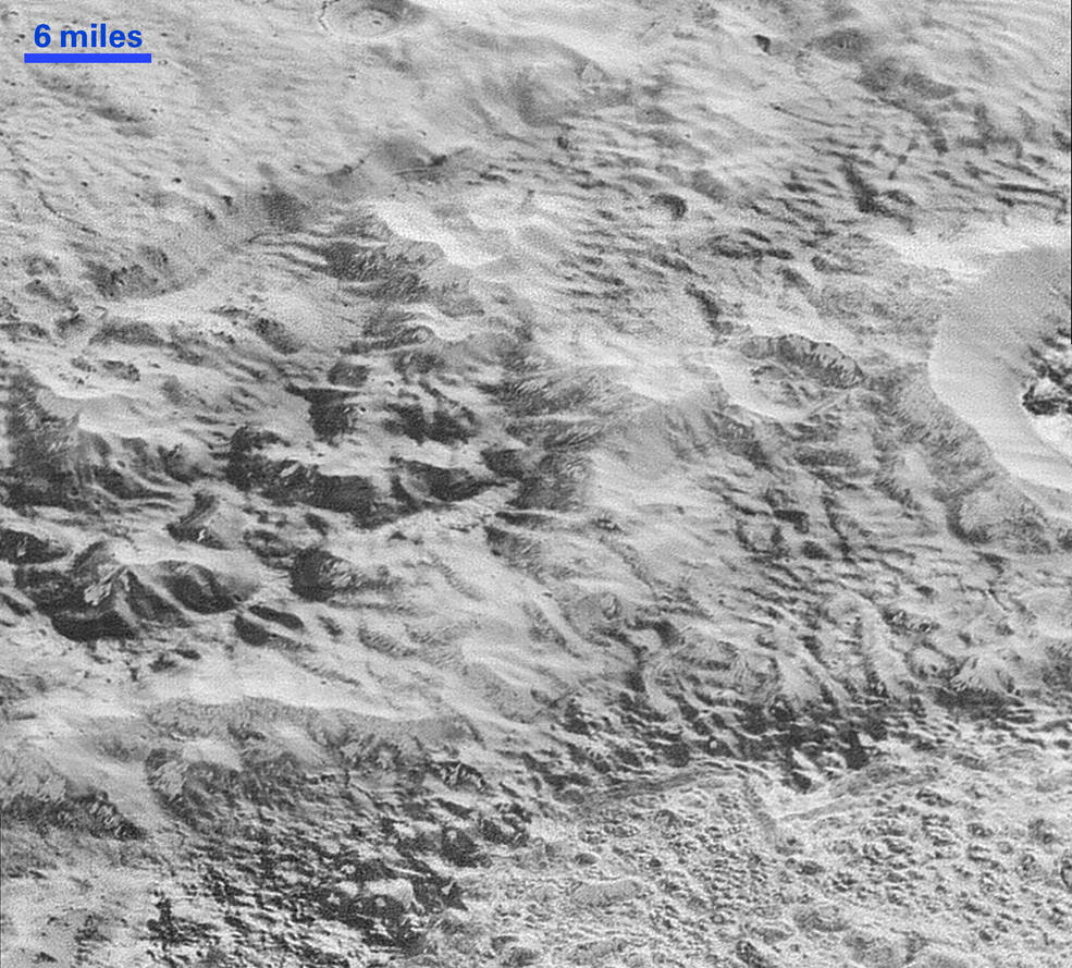
New Horizons has transmitted back to Earth the closest and sharpest images of Pluto's surface captured during the July 14 flyby. The resolution of these images is about 250-280 feet (77-85 meters) per pixel – "revealing features less than half the size of a city block on Pluto’s diverse surface."

“These new images give us a breathtaking, super-high resolution window into Pluto’s geology,” said New Horizons Principal Investigator Alan Stern, of the Southwest Research Institute (SwRI) in Boulder, Colorado. “Nothing of this quality was available for Venus or Mars until decades after their first flybys; yet at Pluto we’re there already – down among the craters, mountains and ice fields – less than five months after flyby! The science we can do with these images is simply unbelievable."

In this highest-resolution image from NASA’s New Horizons spacecraft, great blocks of Pluto’s water-ice crust appear jammed together in the informally named al-Idrisi mountains. Some mountain sides appear coated in dark material, while other sides are bright. Several sheer faces appear to show crustal layering, perhaps related to the layers seen in some of Pluto’s crater walls. Other materials appear crushed between the mountains, as if these great blocks of water ice, some standing as much as 1.5 miles high, were jostled back and forth. The mountains end abruptly at the shoreline of the informally named Sputnik Planum, where the soft, nitrogen-rich ices of the plain form a nearly level surface, broken only by the fine trace work of striking, cellular boundaries and the textured surface of the plain’s ices (which is possibly related to sunlight-driven ice sublimation). This view is about 50 miles wide. The top of the image is to Pluto’s northwest. Credits: NASA/JHUAPL/SWRI
This highest-resolution image from NASA’s New Horizons spacecraft reveals new details of Pluto’s rugged, icy cratered plains. Notice the layering in the interior walls of many craters (the large crater at upper right is a good example). Layers in geology usually mean an important change in composition or event, but at the moment New Horizons team members do not know if they are seeing local, regional or global layering. The darker crater in the lower center is apparently younger than the others, because dark material ejected from within – its “ejecta blanket” – has not been erased and can still be made out. The origin of the many dark linear features trending roughly vertically in the bottom half of the image is under debate, but may be tectonic. Most of the craters seen here lie within the 155-mile (250-kilometer)-wide Burney Basin, whose outer rim or ring forms the line of hills or low mountains at bottom. The basin is informally named after Venetia Burney, the English schoolgirl who first proposed the name “Pluto” for the newly discovered planet in 1930. The top of the image is to Pluto’s northwest. Credits: NASA/JHUAPL/SWRI
This highest-resolution image from NASA’s New Horizons spacecraft shows how erosion and faulting has sculpted this portion of Pluto’s icy crust into rugged badlands. The prominent 1.2-mile-high cliff at the top, running from left to upper right, is part of a great canyon system that stretches for hundreds of miles across Pluto’s northern hemisphere. New Horizons team members think that the mountains in the middle are made of water ice, but have been modified by the movement of nitrogen or other exotic ice glaciers over long periods of time, resulting in a muted landscape of rounded peaks and intervening sets of short ridges. At the bottom of this 50-mile-wide image, the terrain transforms dramatically into a fractured and finely broken up floor at the northwest margin of the giant ice plain informally called Sputnik Planum. The top of the image is to Pluto’s northwest. Credits: NASA/JHUAPL/SWRI

The following movie is composed of the sharpest views of Pluto that NASA’s New Horizons spacecraft obtained during its flyby on July 14, 2015. The pictures are part of a sequence taken near New Horizons’ closest approach to Pluto, with resolutions of about 250-280 feet (77-85 meters) per pixel – revealing features smaller than half a city block on Pluto’s diverse surface. The images include a wide variety of cratered, mountainous and glacial terrains – giving scientists and the public alike a super-high resolution view of Pluto’s complexity.

To access the full features of Pluto Safari please download the FREE app for iOS from the Apple App Store or Pluto Safari: New Horizons for Android from Google Play.

Alternatively, if you have SkySafari or Pluto Safari installed you could download the simulation settings file here.