New Map Helps to Decipher the Pattern Of Bright And Dark Markings On Pluto's Surface
by Sophia Nasr, @Pharaoness
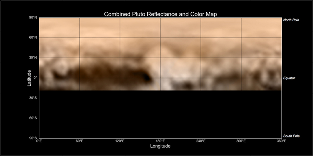
You’re looking at the latest map of Pluto, created using high-resolution imagery from the Long Range Reconnaissance Imager (LORRI) aboard the New Horizons spacecraft combined with color data from the Ralph instrument. The center of the map shows the area of Pluto that New Horizons will flyby the closest on July 14th.
Having this map gives scientists an easy way to compare the dark and bright areas across Pluto and figure out what they are.
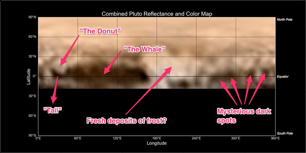
If you look at the left side of the map along the equatorial region, you’ll see a dark area that’s shaped like a whale. The "whale" is 3000 km (1860 miles) in length, which amounts to 40% of the circumference of Pluto.
To the left of the whale, where its "tail" is located, lies a bright donut-shaped area, 350 km (200 miles) in diameter. While it looks crater-like, with its circular shape resembling craters or volcanoes seen on other planets and moons, scientists are not drawing any conclusions until higher resolution images are obtained. Such images will come as the spacecraft approaches closer to the Pluto system in the coming days.
To the right of the whale’s head is the brightest region on Pluto’s surface, some 1600 km (990 miles) across. The bright region may be where frozen methane, nitrogen, and/or carbon monoxide, all constituents in Pluto’s atmosphere, are deposited.
The famous four dark spots, each hundreds of kilometers across, that have intrigued scientists and enthusiasts, are located further to the right of the bright region.
"We’re at the ‘man in the moon’ stage of viewing Pluto," said John Spencer of the Southwest Research Institute, Boulder, Colorado, deputy leader of the Geology, Geophysics and Imaging team. "It’s easy to imagine you’re seeing familiar shapes in this bizarre collection of light and dark features. However, it’s too early to know what these features really are."

New Horizons is now just over 7,600,000 km from Pluto. The spacecraft will flyby Pluto in 7 days, and make history in revealing this distant world in detail for the first time.
For the original press release, click here.
 Sophia Nasr is an astrophysics student at York University. Actively involved in the astronomical community at York U, she is the President of the Astronomy Club at York University and a member of the team at the York University Observatory. She also is involved in university projects, and holds a position in research on dark matter at York U. Holding scientific outreach dear, Sophia is actively involved in social media outlets such as Facebook, Twitter, and Google Plus, where she shares with the world her passion for the universe and how it works.